Disaster displacement in context: Household trajectories after the 2018 Central Sulawesi multi-hazard event
Abstract
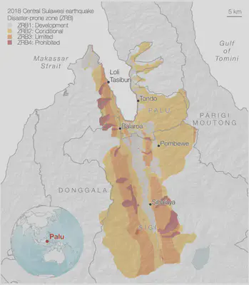
Disaster risk assessment has traditionally emphasized physical damage and economic loss, which can overlook the uneven hardships that disasters impose on households. Human-centered metrics aim to help address these concerns, with household displacement increasingly gaining attention as an alternative risk metric that can inform broader and more equitable decisions. However, limited contextual information and long-term data preclude adequate understanding of how households experience disaster displacement differently. This study examines household mobility over six years following the 2018 Central Sulawesi earthquake, tsunami, and liquefaction disaster in Indonesia. Using household surveys, we track the evolution of household decisions, living standards, and wellbeing across multiple relocations over time. The results show that while most households return quickly and relocate short distances, there is substantial variation in the duration and severity of displacement. Households relocating to tents, outdoors, or in other sheltering conditions report limited agency over their choices, poorer living standards, and higher rates of sleep difficulties and anxiety compared with households staying with family/friends or in dedicated temporary housing. Initial relocations were driven by concerns about disaster risks and trauma, as well as housing and neighborhood conditions. Six years later, concern about disaster risks no longer dominates relocation decisions, as households prioritize neighborhood conditions and social networks instead. We further disaggregate displacement trajectories by household-level factors, including damage, income, tenure, and place attachment, offering insights into how displacement risks are unequally distributed.
Example figure
Nicole Paul
ETH Fellow
Exploring how disaster risk models can inform shelter and housing assistance decisions in earthquakes, tropical cyclones, and floods