Development of a uniform exposure model for the African continent for use in disaster risk assessment
Abstract
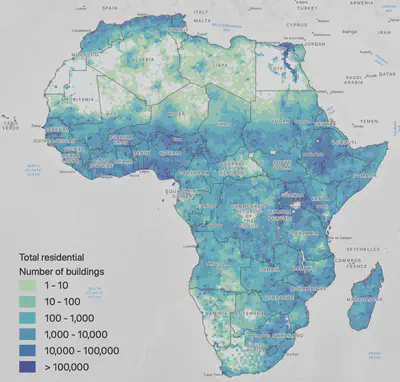
Several destructive natural hazards have occurred throughout Africa over the past century, yet few comprehensive exposure models exist for the continent. The high population growth and rapid pace of urbanization within many African countries entail a significant potential for increased economic and human losses, particularly where substantial urban growth encroaches upon hazard-prone regions with inadequate land management and building design regulations. This study introduces a new exposure model for all African countries using national and global datasets with a uniform approach across the continent, developed for a baseline year (2020) and six future years (2025, 2030, 2035, 2040, 2045, and 2050). The exposure model was originally derived with subnational statistics, and then further spatially disaggregated using Earth Observation (EO) data. This refined spatial resolution allows the model to reflect a realistic population distribution within each country and thereby better characterizes the potential risk to natural hazards and allows identification of disaster risk hotspots. The results indicate the current concentrations of building stock in Africa, in addition to regions where the urban building stock is expected to nearly triple (such as in Central and East Africa) or at least double (such as in West and South Africa).
Example figure
Press
- “New Hazard Exposure Model for Africa” by Munyaradzi Makoni for EOS
- “Mapping exposure of urban and rural communities to natural hazards” by Nicole Paul for Africapolis
Policy documents
- Africa’s Urbanisation Dynamics 2025: Planning for Urban Expansion by the Organisation for Economic Co-operation and Development (OECD), 2025
- Building Regulations in Sub-Saharan Africa: A Status Review of the Building Regulatory Environment by the World Bank Global Facility for Disaster Reduction and Recovery (GFDRR), 2023
Nicole Paul
ETH Fellow
Exploring how disaster risk models can inform shelter and housing assistance decisions in earthquakes, tropical cyclones, and floods